The terrain of an open-pit mine changes every day. Benches are cut, material is moved to dumps and stockpiles, and haul roads are built and relocated. Any digital twin of a mine therefore needs a reliable way to capture the shape of the site and update it. Drone LiDAR is one of the methods used for this.
What LiDAR Is
LiDAR stands for Light Detection and Ranging. A LiDAR sensor emits laser pulses and measures the time each pulse takes to return after hitting a surface. From this, it calculates distance. When the sensor is mounted on a drone with accurate positioning, it records millions of measured points across the site.
The result is a point cloud: a set of points in three-dimensional space that represents the surfaces the laser reached.
What the Data Produces
Raw point clouds are processed into products that are easier to use:
- Digital Surface Model (DSM): a surface that includes everything the laser hit, such as equipment and structures.
- Digital Terrain Model (DTM): a surface representing the ground after non-ground objects are removed.
- Contours and cross-sections: used by engineers for design and checking.
- Volume calculations: comparing two surveys of the same area shows how much material has been moved.
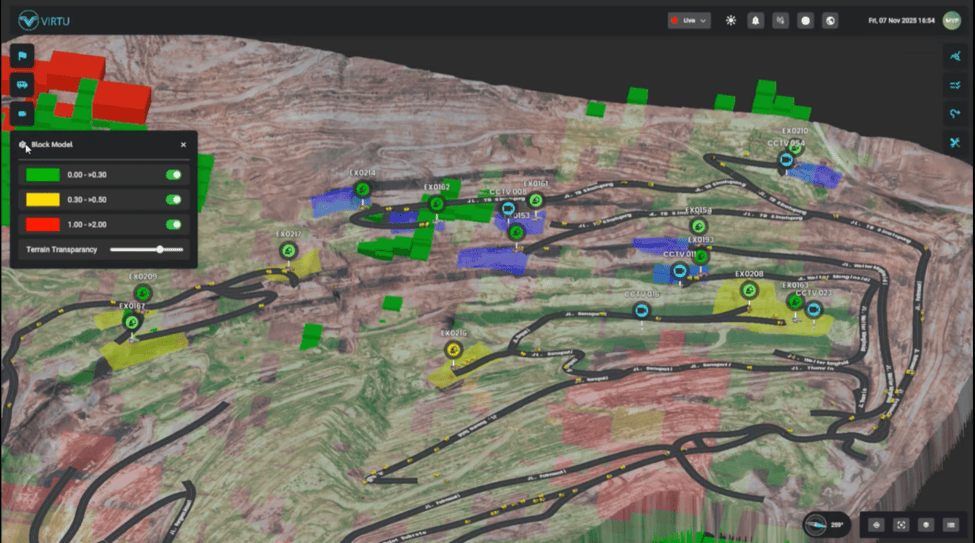
In a digital twin, the processed terrain surface becomes the base layer on which equipment and operational data are displayed.
LiDAR vs Photogrammetry
Drone surveys in mining usually use one of two methods.
Photogrammetry builds a 3D surface from many overlapping photographs. It produces visually detailed results with colour, and the equipment is generally less expensive.
LiDAR measures distance directly with laser pulses. Some laser pulses can pass through gaps in vegetation and reach the ground, which can be useful in areas with plant cover. LiDAR also depends less on lighting conditions than photography does.
Many operations use both methods, or combine LiDAR geometry with photographic colour.
The choice between the two depends on the site’s vegetation, the accuracy required, the size of the area and the budget available. Both methods produce data that can be used as the terrain layer of a digital twin, provided the outputs are processed into a consistent surface format.
How Virtu Uses Drone LiDAR
In Virtu’s Smart Digital Twin Mining project for Petrosea, drone LiDAR was used to create a detailed virtual map of the mining infrastructure. According to Virtu’s project page, the map is intended to be updated over time so that changes in the terrain can be followed as excavation progresses. The terrain layer was then combined with live data from Petrosea’s Fleet Management System.
Virtu’s digital twin page also notes that a 3D topographic view gives more useful context than a flat satellite map for a worksite that changes constantly.
Survey Frequency
How often a site should be surveyed depends on the rate of change and the purpose of the twin. Factors to consider include:
- the speed of excavation and dumping
- the needs of short-term planning and reconciliation
- the cost and availability of survey flights
- the time required to process each survey into a usable surface
A digital twin used for daily operational awareness needs more frequent terrain updates than one used mainly for monthly reporting.
Data Quality Considerations
Several factors affect the accuracy of LiDAR terrain data:
- the accuracy of the drone’s positioning system
- the use of ground control points to check and correct positions
- flight height and point density
- weather, dust and moisture during the flight
- the processing steps used to separate ground from non-ground points
Survey teams should document these settings so that results from different flights can be compared reliably.
Safety and Access Benefits
Drone surveys reduce the need for surveyors to walk near active faces, highwalls and stockpiles. They can also cover large or difficult areas in a shorter time than ground-based methods. Flights still need to follow site rules and aviation regulations, and they must be coordinated with active equipment.
Summary
Drone LiDAR provides the measured terrain surface that forms the base of a mining digital twin. Regular surveys keep that surface current as the pit changes. Mining companies planning a digital twin can contact Virtu to discuss how terrain data from their site can be integrated.